American Sabbatical 100: 4/23/97
End of the Trail
4/23... Oklahoma Mountains.
Spanish voices awoke us in Texarkana. We were crossing boundaries again. The instructions
in the motel room were in English, French, and Spanish, and the
local cuisine ranged from longhorn burgers to crawfish to Tex-Mex.
The kind of place where you might learn about diversity. Hope,
Arkansas, is only 30 miles away. Boulder is a thousand and thirty,
however, so we didn’t go looking for Hope, or take the cure at
Hot Springs. We were galloping toward Eastern Oklahoma. The end
of the Trail of Tears. Indian Country.
The road ran uphill. We’d crossed into sedimentary uplands, where
layered orange outcrops break surface, and three woodland domains
overlap. The great Eastern woodlands, the Southern forests, and
the Texas brush country. Hickories and maples and the whole tribe
from Tennessee mingled with the low country evergreens, pines
and live oaks, while the edges were tangled in hackberries, buttonwoods,
scrub oaks. Not at all my image of Texarkana.
Logging country, big rigs in your face, and a Georgia-Pacific
megamill sulfuring the air.. waters too, no doubt. I’d assumed
that our homegrown paper plantation was relatively unique. Nowhere
else but Maine was the pulp trade so pernicious. Now we’ve seen
that money grows in trees everywhere trees grow. Deep South, Pacific
Northwest, and now in Arkansas and Eastern Oklahoma. These wooded
hills stink of papermaking just as bad as Plantation Row smells
of oil refineries. Whenever Peggy rhapsodizes about the lovely
pines, I see monocropping, and get nervous. I remember the spruce
budworm in Washington County, and the resulting fastbuck economy
of liquidation clearcutting. Which excess will we choke on first,
petroleum or paper?
The woods ARE lovely, though. Not all pine plants, either. As
we elevate, we’re rolling the calendar back again, to young pastel
leaves and blooming hardwoods, to Spring. An occasional pecan
grove, even, to hush my mouth. In Arkansas the pecans are in bloom.
Not showy flowers but dense bronze droops, and the groves are
carpeted in blue and scarlet flowers.
North of Texarkana we followed a red road until the heavy breathing
truckers made us want to hang up. Then we cut west on lesser arteries,
and crossed into Oklahoma. Red flashes flicked across our peripheral
vision: courting cardinals. Egrets policed the pastures among
Red Angus and crimson clover. Every dozen miles or so the shoulder
flowers would change, mingle, permute.
Fifty miles north of Broken Bow our ears started to pop. We were
climbing into serious mountains. In Oklahoma? Sure enough. The
Kiamichi Range of the Ouachita Mountains. You might be in New
Hampshire. Leaves just peeking on the northern slopes. Sweeping
vistas across crooked lakes at receding rows of peaks. Mr. and
Mrs. Hillhungry pulled down a logging road, and let the Owl cool,
while they stretched a limb or two. Communed with the orange god.
Broke bread. And finished the morning tea. I put on my vest. So
long sultry sunlands. Hello hill breezes.
If you squint, the country from Big Cedar to Poteau could be highland
Georgia or Alabama, and we kept encountering Choctaw Nation sites.
I was quickly modifying my image of woodland Indians being driven
out onto treeless prairies. Granted, the Choctaws removed here
early enough to get first dibs, but the hardship of leaving rich
familiar lands seems less cruel when you see how fine upland Oklahoma
is.
Now these lakes and mountains are trying to attract tourists as
recreational resort areas, and the sideroads invite us with wave-runner
rentals, and bait for sale signs. Maybe it’s early in the season,
but this Native American destination looks a bit seedy and down-at-heel
to me. We didn’t want to buy a pontoon boat, either.
We’d climbed out of the Red River Valley. Now we descended toward
the Arkansas, and another visit to the Mississippian era. The
westernmost outpost of that far-flung culture sat on a bend in
the Arkansas at Spiro, Oklahoma, circa 1000 AD.
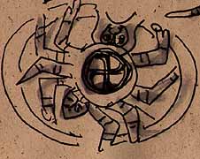
Spiro Spider
(Memo #96)
|
Apr 23 Spiro mounds
Who? Mississippian peoples
What? population center with 9 platform mounds
When? height of development 800-1200AD
Where? flatland by Arkansas River
How? wide system of trade and tribute under a Chiefdom
Topics: prehistory, mound sites, Mississippian culture
Questions: What are the common characteristic of Mississippian
peoples? What are the differences between the far flung sites?
What happened to the Mississippians and how do they relate to
the tribes the English colonists found?
|
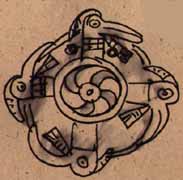
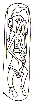
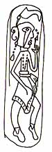
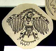
Spiro Mounds Gorget
|

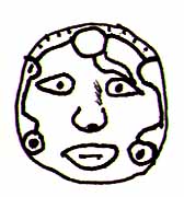
Face Motif
|
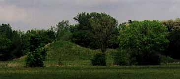
We’ve been to four other Moundbuilder sites before Spiro (spy-row).
Cahokia (in East St. Louis), Ocmulgee and Etowah in Georgia, and
wonderful Chucalissa (the reconstructed village at Memphis, Tennessee).
We were excited at the prospect of seeing Mississippian mound
sites in the West and had targeted Spiro in Oklahoma. Spiro is
located on the flats by the Arkansas River surrounded by fields
and woods. As we drove in by a country road, we saw the clean
lines of the big dirt pyramid beyond the trees and felt at home.
|
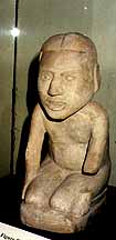
The entrance building is tiny and the museum is one room full
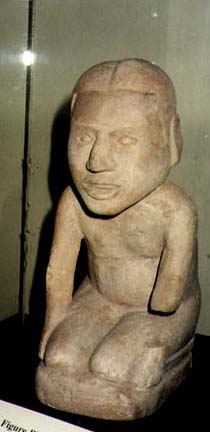
of exhibit cases. The contents are wonderful: incised conch shells
from Florida, incised gorgets (large pendants), elaborate coppers,
effigy figures, pipes, pottery of many shapes, flint and bone
tools, jewelry (beads and gorgets and ear plugs), evidence of
a variety of weaving techniques with cane and textiles. It was
very exciting when I discovered that a stylized raccoon I’d sketched
at Ocmulgee in central Georgia has a twin on a piece here at Spiro,
hundreds of miles away! The exhibits pointed out other design
motifs that are shared throughout the Mississippian area (a sun
circle, a cross). Archaeologists prove contact between peoples
by clues like this. There are also trade goods that show the distances
knit together in Mississippian times, conch from Florida, copper
from the Great Lakes, lead, quartz. The quarries for many of the
important rocks and metals have been found by Archaeologists.
|
Figure
|
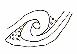
Spiral Dots?
|
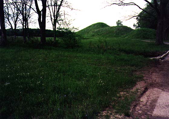
Spiro was at its height from 800-1200 a.d. Its rise is explained
by its location: it’s a “gateway” to the system of rivers that
flow into the Arkansas and it is rich in natural resources. Flint
is available, the soil is rich (both upland and bottom land),
and there was a lot of game. Spiro held together 15 village centers
in Oklahoma in a Chiefdom. It must have been fairly peaceful as
Spiro was unfortified. |
| We watched the slide show and our hearts sank. Apparently the
Spiro Mounds had been “mined” literally by a COMPANY organized
to uncover and sell artifacts in the 1930s. The pictures showed
the destruction at the site, huge trenches dug through the mounds,
the dirt simply sifted for goodies and dumped. The narrator stressed
the loss to science from bad techniques. No one knows how many
artifacts were found or where. The remaining ones seem special
enough to make us sigh. |
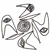
Eye Boomerangs?
|
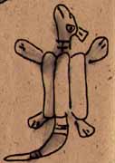
Turtle in Lifejacket
|
My grad school advisor Dwight Heath did a study of grave robbers
in Costa Rica that estimated their share of the GNP at 10%. The
grave robbers later used his statistics from an anthropological
journal article to lobby the national assembly for recognition
as a union!! |
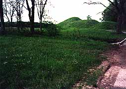
| The slides also showed the archaeological digs stripping down
the mounds. Hmm. We got a battered guide booklet and set off across
the field. There are paths to the two mound groups with observation
spots. Unlike the other three Mississippian sites we’ve visited,
there are no stairways up to the top of the mounds. It’s look-at-from-a-distance
at Spiro The numbers on the tour points are almost unreadable
and the information boards warped and leaning. The whole place
had an air of neglect that was very sad. The photos made it obvious
that the present mounds had had to be partially reconstructed.
There seems to be uneven lines to most of the mounds from all
the disturbances. The biggest one is the size of the small ones
at Etowah and Ocmulgee. Near the woods there is the unfinished
skeleton of what obviously was to be a reconstructed dwelling,
an interrupted project . For whatever reason, Spiro has not been
maintained as a vital tourist attraction and it’s the only archaeological
site noted on my Native America guide in Oklahoma. |
|

Actual Gorget
4/24.. cont.
Peggy’s memo doesn’t do Spiro justice. It looked like the Memphis of the Mississippian. Gravediggers
have looted the pyramids, and the city fathers have torn down
all the old buildings. Collapsing signs in flat fields described
mounds that HAD been there. What lumps were left were deeply gnawed
and eroded. The one staffer guarding the entrance for the State
of Oklahoma was busy watching a gameshow on his portable TV, and
couldn’t answer a single question about the collection or the
site.
Spiro Mounds
Effigy
|
The site stands deep in last year’s hay, glinting bronze and iridescent
white, except for a few mowed paths, and some cut acres that are
coming back in green grass. The mounds are covered with a whole
botanical of flora, half of it in bloom. The three biggest mounds
are being encroached on by a grove of trees, and the black locusts
among them are covered in clusters of blossoms, white pea-shaped
blooms perfuming the ancient grounds. A mild wind is shaking the
straw and the locusts, and a dozen different wildflowers are shaking
among the grasses. The quiet beauty of this place makes us smile.
The hokieness of the presentation makes us laugh. |
| And another thought rises up in the meadow. If, as is now believed,
the civilized tribes are the descendants of the Mississippian
people, their resettlement from the southeastern quadrant of their
ancient culture area to this, the western part of that empire,
has a certain symmetry.. if little justice. |
Mounds of Flowers
|
Spiro Incisions
|
We have time for one more visitation today. Sequoyah’s House,
just across the Arkansas in Sallisaw. You may remember that we
flew through here last December, hurtling home for Christmas,
and I promised Peggy we’d come back to Sequoyah’s. (You don’t?
There WILL be a final exam on all this.) Now we’ve finally crossed
our back trail. First time in 25,000 miles (not counting the home
turf). And Peggy has pin-pointed these Cherokee sites as some
kind of culmination. The end of the Trail of Tears is her last
“BIG ONE”.. ending our Southern Journey. |
If Kate Chopin’s House was a Mom Museum, Sequoyah's is a Pop Shop.
The caretaker took Peggy around the sacred ground. But I’ll let
her tell the tale.
(Memo #97)
Apr 23 Sequoyah Home
Who? Cherokee man who invented alphabet
What? house where he lived in Oklahoma
When? 1820’s
Where? eastern Oklahoma
How? moved from East
Topics: literacy, alphabets, Cherokee history
Questions: How did Sequoyah develop an alphabet? What inspired
him? |
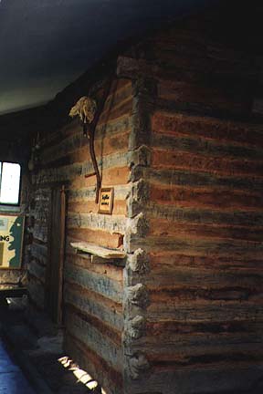
Cabin in a box
|
It is an astounding story. Sequoyah was an illiterate Cherokee
who learned about reading and writing from missionaries and decided
his people needed to have them. He clearly saw the connection
between literacy and empowerment. So he invented an alphabet (some
call it a syllabary - more on that below). It took him twelve
years. Sequoyah is said to be he only INDIVIDUAL in history known
to invent an alphabet.
Although his alphabet is shown at every site associated with Cherokees
in Georgia and Oklahoma, the only site I’ve seen associated with
Sequoyah himself is his home in Oklahoma. We had been unable to
stop on our fast trip east in December and I have been looking
forward to a promised return ever since. The Cherokee sites in
Georgia were so exciting (see Memo #85) that Oklahoma seemed an
ideal end to our second trip.
Sequoyah’s life shows the complexity of Cherokee history. His
mother was Cherokee and his father was white. He was born in Tennessee
about 1775 and known in English as George Guess. He fought in
the War of 1812. He was one of the Cherokee who moved west before
the Removal, to Alabama in 1800, then to Arkansas in 1822 (having
visited first). He apparently had a salt making business in Arkansas.
He signed the Treaty of 1816 and was a representative of the Arkansas
Cherokee (known as “Old Settlers”) who went to Washington in 1828.
The Cherokee immigrants were forced out of Arkansas (another removal!)
and Sequoyah came to Sallisaw, Oklahoma around 1828. Sequoyah
exchanged his Arkansas salt works for one near Sallisaw Oklahoma
that he operated until his death. The Dwight Mission was located
near Sallisaw and Sequoyah apparently used its press. He died
in Mexico (!) where it is said he had gone to locate a “lost band”
of Cherokee.
We drove out the roads from Sallisaw. The small lane to the homestead
is marked with a sign in English and Cherokee. The site has stone
walkways and a romantic bronze status of Sequoyah. The D.A.R.
has a stone fountain by a walkway.There is a separate office in
a log cabin, the spring that Sequoyah dug still bubbles at the
bottom of the hill and a small ”Sequoyah” tree is fenced in nearby.
The California trees were named in his honor - I’m not sure why
a tree.
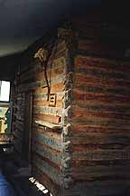
Sequoyah’s cabin is in a “shrine”, a stone building that totally
encloses it and was built as a CCC project in the 1930’s. Far
from sitting in a bucolic clearing or field, Sequoyah’s cabin
is in a temperature controlled stone container like a second skin
that only allows you to stand about fifteen feet back from it
(so you can’t take a full picture). It was weird especially since
the building is way out on a country road in Oklahoma ranch country.
It is definitely a museum with an exhibit rather than a “site”.
After the buildings at New Echota dispersed along dirt roads in
woods and fields, it was very disconcerting to tour a cabin by
artificial light inside a building. There are a number of exhibit
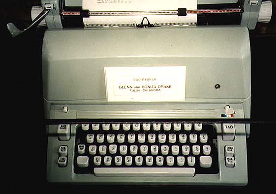
cases. The most interesting held a Cherokee typewriter with his
characters. There are a few objects he made, including a plow
and a spinning wheel. The cabin is simply but completely furnished
with “period” items - table and chairs, bedstead, frontier items
like a gun and churn. You see it from the doorstep. There was
a chart showing alphabets of the world.
Sequoyah’s 1821 system has about 85 “characters”, some are from
English, some look Greek, some are unique. There are ones that
are identical in form to the English letters D,R,T, L,G,V (although
they stand for other “sounds” in Cherokee). Usually Sequoyah’s
invention is called an “syllabary” because each written symbol
stands for several sounds. For example, the curly E symbol stands
for “que” (three English “letters” make up the “syllable”). I
find the argument (alphabet or syllabary) silly. It is an example
of categories which divide and perhaps devalue. WE have an “alphabet”,
the Cherokee have a “syllabary” (they also had 95% literacy long
before we did). Some call it an “alphabet” as I will.
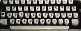
Cherokee Keyboard
Whatever you call it, Sequoyah created a written system for a
language that was simple and effective. The manager said it was
basically “Hooked on phonics”.The system was adopted by the tribal
council in 1821. His people became literate in ten years and started
publishing a newspaper (still published today), books and pamphlets,
Bibles and laws in their own language developed by one of their
own people. The Cherokee taught his system in 18 schools and two
seminaries (colleges) by 1851! The Creek have adapted his system
for their language. The Cherokee use his system today and you
see Cherokee writing everywhere in eastern Oklahoma..
It is an achievement unique in history.
4/24.. cont.
Peggy came back to the Owl biting her lip. She began giggling uncontrollably
as we pulled away from Sequoyah’s shrine. All the anticipation
for an historical climax, and whatdaya get? Another roadside attraction.
What should lawn ornament connoisseurs expect?
We might have suspected. We’d started seeing yardart this morning,
and it got thicker all the way up Eastern Oklahoma. Whirligigs
and outlandish metalwork. Even the houses were outspoken. The
older ones are faced with large flags of the local orange sedimentaries,
and we’d OOed and AHed over hill and dale.
On the way back into Sallisaw Peggy began reading from a state
brochure of attractions in Oklahoma she’d picked up at Sequoyah’s.
“The Central High School Museum, with the Class Ring Collection,
yearbooks and photos; The Timberlake Rose Rock Museum, a house
build of thousands of stones from historic places.. dedicated
to Oklahoma’s official State Rock (the barite rose); Showman’s
Rest/Mt. Olivet Cemetery, unusual monuments of circus performers..
burial place of champion bull riders Freckles Brown and Lane Forest;
the National Lighter Museum, firestarters of all kinds; the Higher
Education Hall of Fame; the Lee Way Motor Freight Museum, Inc..
memorabilia from a trucking corp... featuring tire irons; the
USS Batfish, a WWII submarine; the Oklahoma Prisons Historical
Museum; the Percussive Arts Society Hall of Fame; the Laverne
Museum, with Miss America Jane Jayroe items, and a 1000-plus shoe
collection..” Peggy was laughing uncontrollably.
We decided to simply stay in Oklahoma, and report on all these
sites for you. There’s really too much to see here, so what’s
the point of rushing on to “see America?” THIS IS IT. Special
events coming up are the Rattlesnake Roundup, and the Annual Outhouse
Race. We think Bowdoinham should institute the Annual Smelt Shack
Race, and invite Oklahoman outhouse race winners to come as a
special attraction. Oklahoma obviously has a lot to teach Maine
about tourist attractions. Who says the Indians stopped raiding
the wagontrains?
Our Trail of Tears ended here. We laughed so hard we cried. To
cap it off we recrossed the Arkansas in Sallisaw to chow down
at another restaurant recommended by the roadfood guide. The Wild
Horse Barbecue. Pork ribs (we hoped) and hot sauce with beans,
served on styrofoam at picnic tables. MMmm. We’ve really found
the heart of America.