American Sabbatical 027: 10/6/96
Missoula & Lochsa
10/6.. Missoula.
When I started to resurface after the episode at Papa-T’s, Peggy began to have an allergic
reaction to Missoula (another smutchy town), and we waved on the
way to bed. I hate to think what LA is going to do to us.
In Missoula we spent an evening with the locals in Cynthia’s back
yard hearing the native gossip. Sounds a lot like Maine. In fact
Montana feels very familiar after 23 years beyond the Piscataquis..
same pace, same open welcome in front of a guarded reserve, same
observant curiosity, same smell of leaves in the fall, same pickups..
call it hinterland Americanish. Only the hills are bigger.
This year’s eco-controversy on the Montana ballot is a new water-quality
law, which the green-hats say has been watered-down (higher ppb’s
in some categories), while the mining industry (black hats) is
crying local shutdowns and mega-ripple effects. Does this sound
familiar to you Mainers scratching your heads over the clear-cutting
ban? All we could say was “don’t drink the water,” and “what about
the stink in the air?” The Montana papers have been full of op
eds about the invasion of eco-tourists and carpetbagging developers,
and how it’s all the sports fishing pressure that’s spreading
whirling disease (a sort of mad fish disease). Even the wildlife
is pissed. Reports of wildcats attacking hunters (reeking of elk
rut), and bison goring tourists (Arpege) are frontpage news. These
Montana rags are a joy. They are handsome and colorful, and the
national news is NEVER the lead! A couple of inches here and there
on clintondole and natanyahuarafat then back to bear maulings.
(In Wyoming the big row was over a proposed law that bronco-riders
wear helmets. Wimp-attack.)
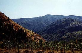
The logging around Missoula is primarily for log home construction.
The road we came in on was lined with cranes assembling kit houses,
sort of BIW for Lincoln Logs. The wrinkle is that the logging
(on fed lands, natch) is sub-contracted to migrant Hispanics who
make their profit margins by selling their by-cut as firewood.
So concerns about cutting practices are confused with class guilt.
Maybe IP should borrow a page from DeCoster and import labor from
Chiapas.
The suburban slopes in commuting range of these western burgs
are dotted with the egofices of todays upper middlers. As in Maine,
nobody is building modest housing, and condos are a glut on the
market. Nobody moves to Montana to share a wall with anyone. Give
me land, lots of land, with an endless driveway up.. And most
of the building is log. We thought the log hotel at Yellowstone
was impressive, but some of this cantilevered moderne is big as
all outdoors.
The only other architectural excitement in the Montaine has been
the hayArt. Out in the grassland prairie of the Dakotas and Wyoming
each county seemed to have its own style of stacking, maybe by
ordinance. In old fashioned bales, bigrolls, superbales, or loose,
there would be blocks or rows or geometrical spacing or, grandest
of all, pyramids. Sometimes old hayArts would have weathered down
into gigantic versions of the ancient haystack, or Chicken Itza.
But Montanans do hay in the grand manner. In Big Hole the lush
crop is built into immense loose hay buildings, like thatched
barns, and surrounded with split-rail fences to keep the beef
away until the snow gets deep. They use great frame catapult things
to compose the masterpieces, and the Big Hole Valley’s straw buildings
create an Icelandic landscape for giants. (The Big Holers also
take pride in their rail fences, and build towering old-style
swinging rail gates where the heifers dare to tread.) Of course
there’s always a joker. We saw a hay house with windows and doors
and figures in same, and the legs-coming-out-of-the-bigroll motif
has become cliched here (Maine ornamenteurs take note).
On Saturday we found the strength to visit the farmers’ market,
because Peggy has been moaning “green?” for weeks. And it was
good to see that college-town culture is keeping the 60s alive
even out here by the Bitterroots. Barefoot Trustifarians and pierced
leatherheads were busy hawking tie-dyed Buddhism and Times Square
jewelry. There were also vegetables, I mean the edible kind. These
places make you feel young again, don’t they? Or is that embarrassed
self-recognition, not flashback? Isn’t it gratifying to realize
our generation left a lasting cultural pattern in the historic
medley? Groovy. We had to go “home” and lie down again.
10/7.. Lochsa.
| When we finally got up it was Monday. Cynthia and her two neat kids, Rhys and Lizzie,
had nursed us back to health with home cooking and a house full
of laughter, but Festiva was neighing in the driveway and Farther
was calling. Our thought had been to make a Beeline for the coast
and descend on all you outer fringers, but the immediate threat
of Superhighway Syndrome was paralyzing to our convalescing selves.
So we backdoored out of Missoula through Lolo. |
Lolo Pass
|
And I’d been troubled by voices in the night again. This journey
has been very much an outer odyssey. Concerned with modem strings
and highway numbers, milespergallon and springwater, compass bearings
and historic references. We’ve rarely honored a psychic sabbath,
let ourselves be swallowed by silence, or held in trance. My daily
rituals of silencing the inner dialogue have been abandoned. We
have a constant outer dialogue.. and there’s this puter noise.
Only when we stop and draw do we act out into The Other, and the
stuff is so unsatisfying to look at that we are skimping that
ritual, too. IT has grabbed us at times, to be sure. We are open
to the holes in the landscape, but our ball is often rolling too
fast to drop through. I can suppress my spiritual anxiety somewhat
by arguing that we are mounding up piles of raw stuff for creative
imagination to wallow in later, but the fact is we’ve let the
Pragmatic American Spirit ride the lead horse. Of course this
is the American story: don’t mind the light in the wood, ride
on. But I’ve spent a long time learning how to see that light,
and this quest was supposed to be seeking a shining in the hills,
too.
So here we are, teetering on the top of America, about to rush
downslope to old friends and family, and all that good peoplestuff,
and I wanted to pause, inside, if not in fact. So we agreed not
to hurry down the Interstate, at least. And we found the dream
road down from the high country.
Along the dream road
|
We'd picked up Lewis and Clark’s trail around Dillon, without
knowing it. My reading of the texts last year didn’t make the
historic path very clear once L&C left the Missouri drainage.
They, of course, were lost, too. Once we encountered the more
detailed local maps, we rediscovered ourselves. So in the agonies
of chicken-fried aftermath we’d staggered up their trail along
the divide. We, too, had tasted the bitterroots. |
The passage from the Atlantic headwaters to the final descents
onto the Pacific slope were always the hardest miles for travelers:
Lewis and Clark, mountain men, or the emigrants behind them. Those
roads the most obscure and difficult. The forage, game, and water
the most scarce. The time most fleeting. Winter at hand. At least
the Indians had been helpful.. certainly the Nez Perce.
When we re-turned south in Missoula, we were tracing those first
uncertain steps out of the shining mountains, through Lolo pass.
(On their return L&C parted company at Lolo, seeking better roads,
and pledging to rejoin along the Missouri. Lewis passed through
Missoula en route to his fateful encounter with the Blackfeet,
while Clark went back up the Bitterroot and over into Big Hole.
Much later, after all the promises had been broken, Chief Joseph
fled up the same trace.) With fewer hopes or fears we set off
into Idaho through Lolo pass.
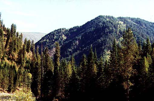
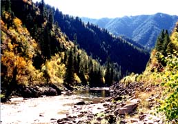
| “Winding Road For Next 77 Miles” the sign said. Folks, this road
may have killed the horses back then, but it is the most soul-lifting
mountain country I’ve ever been in. Imaging driving one long twisting
river valley; hemmed in by soaring peaks; black with towering
spruce, fir and pine; sawtooth mountains rising jagged one behind
another; and a river (as they say) running through it.. all day
long. The landscape is so tilted that you swear at times the river
is running uphill. The switchback curves sway a rhythm in your
bones, and the triangular folds in the shadowed drapery of the
hills keep lilting a tune. This is a road where you keep pressing
your nose against the windshield to see the skyline. |
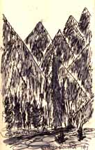
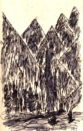
Sawtooth Mountains
|
|
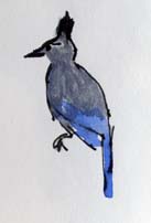
As soon as we crossed over into Idaho these indigo jays appeared
along the road. Idaho bluebirds? Cobalt Ravens of the sky? They
were the only life we saw down the entire Lochsa Valley, for it
was the Lochsa River that dreamed us out of the sky country. Iridescent
indigo birds of transformation, crested like a jay, and with his
moves, but more solid-bodied, and fearless at the roadkills. The
early travelers told of the hungers on this stretch, and it was
the first place in the west where we weren’t confronted with wildlife.
Just these magic birds. [Stellar’s Jay, first reported by Lewis
in these same locals.] |
Partway down the long slope we entered a grove of stupendous cedar
trees. Some six-foot across at the butt and over 200 feet tall.
Clustered together on a slope verging on the Lochsa, cool and
otherworldly, they were the cathedral I’d been empty of. The DeVoto
Memorial Grove, where Bernard DeVoto wanted his ashes scattered,
now maintained by the parks service, they are as fitting a tribute
to the Westering dream as I can imagine. And they made my cockles
leap. We walked slowly through the grove, up and down the slope
to the water. It WAS running downhill. And (yes) we hugged a tree
or two. 1500-3000 years old, the signs said these columns were,
and they put all my demons in the shade. The power places have
opened in our path as we’ve needed them, and now we could come
out of the hills with our spiritbags full.
| But the Clearwater Mountains go on almost forever. I kept stopping,
trying to frame the shot that would tell how these zigged slopes
zag together into a musical tapestry, but it won’t record. It’s
in the twist of your neck, and the tempo of the lightfall, or
something. Even when you think the slope’s run out, and the waters
will slow, the valley straighten, there’s another swing of slopes
and jiggle of sky. O boy. |

Idaho
|
The Lochsa joins the Selway on the Nez Perce Reservation, and
the rough water runs smooth over a near level bed, but we will
tumble downhill for a long while to come. Not that the spectacle
ends at the Selway. But the deep, high, leaping woods do. And
the khaki hills come out to show their bones again. Golden grasses
on the jumbled hills with the river snaking through. We slalomed
the 70 miles to Lewiston with the big rigs breathing on our necks,
and the wrinkled pelts of land shone across the water while we
rode under the tall tree shade on the south bank.
The Selway
|
Lewiston gives you fair warning. Fires had scorched the hills
black for 10 miles, and the plume of effluent air from the Potlach
mill had our eyes watering before the city broke into view. (This
is where the Lewis and Clark party were violently ill from eating
too much Camas root after their long fast. The Resonance strikes
again.) The shock of civilization couldn’t have been more vivid.
Back in rushing autos and a maze of signs out of our soaring dreams,
we immediately got lost. Pulled off the road to regroup, and got
rousted by a hardfaced trooper with no sympathy for transients.
“Move it or you’ll get metal up your ass.” Welcome to Washington.
Might have guessed about a place called Lewiston. |
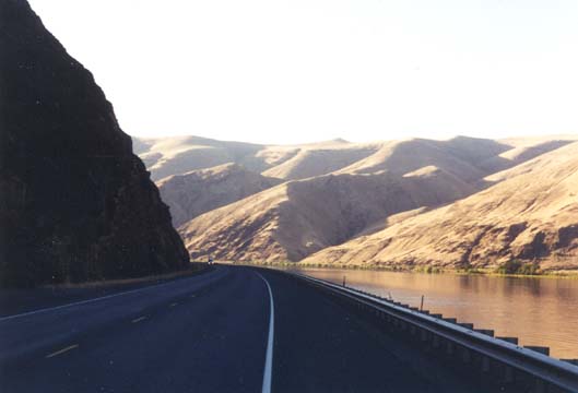
We’d lost our road atlas, had no map of Washington, and were in
a new time zone. A sign said “Hell’s Canyon National Wilderness”,
and we tried to follow the arrows. The Selway flows into the storied
Snake at Lewiston-Clarkston, and Hell’s Canyon of the Snake is
the deepest chasm in North America. If it was just upstream, maybe
we should stare into our deeps. In fifteen minutes we were ambling
along a quite sideroad on the west bank of the Snake in rolling
dry grassland. If there was a gorge here it would have to hurryup
and get orogenic. We asked for directions. AH. Hells Canyon is
90 miles south! Too far for Festivites tonight.
But we weren’t about to try and sleep in charming Lewiston on
the edge of respiratory collapse, hard by the roaring interstate.
So we turned into the sunset and made for campgrounds cataloged
in Free Camping. We went down the Snake.
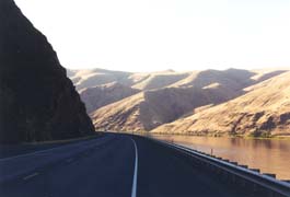
| And into grain-producing country. The edge of the Palouse. Barge-loading
facilities on the river, wheatstraw hills and blackdirt, lush
green intervales, and irrigated croplands. How the weary travelers
must have reveled in the forage here. Your weary travelers crossed
over the Snake into a State Campground dedicated to “Chief Timothy”,
looking for a soft spot. |
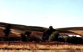
Barn on the Palouse
|
Timothy must be patron saint of the geese. The lush green irrigated
lawns of the campground were hosting a Canada goose convention,
and we’d forgotten our goose boots. Tired as we were, the thought
of lying down on gooseshit was more than we could handle. We rode
on into the sunset.
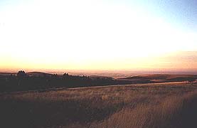
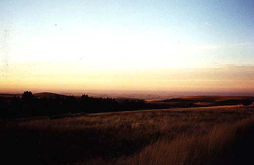
Smoky Sunset
|
Twenty more miles and there was a turnoff for a National Forest,
but 12 miles down that trail we came into heavy plumes of smoke.
The scene was phenomenal. We had risen up to the height of the
plateau and had rolling vistas of grainlands, etched in ruddy
light, with purple smoke trailing across it. We paused to admire
this exaggerated Iowa running to far horizons, picked a bouquet
of the most brilliant blue chicory I’d ever seen, and turned back
to the long road. We lucked into a cozy motel half a mile farther
along the pavement. |

Sunset Palouse